<body><script type="text/javascript"> function setAttributeOnload(object, attribute, val) { if(window.addEventListener) { window.addEventListener('load', function(){ object[attribute] = val; }, false); } else { window.attachEvent('onload', function(){ object[attribute] = val; }); } } </script> <div id="navbar-iframe-container"></div> <script type="text/javascript" src="https://apis.google.com/js/platform.js"></script> <script type="text/javascript"> gapi.load("gapi.iframes:gapi.iframes.style.bubble", function() { if (gapi.iframes && gapi.iframes.getContext) { gapi.iframes.getContext().openChild({ url: 'https://www.blogger.com/navbar/15532271?origin\x3dhttp://eclectice.blogspot.com', where: document.getElementById("navbar-iframe-container"), id: "navbar-iframe", messageHandlersFilter: gapi.iframes.CROSS_ORIGIN_IFRAMES_FILTER, messageHandlers: { 'blogger-ping': function() {} } }); } }); </script>

Tuesday, September 06, 2005

Getting real with Google Earth


Copyright © 2005 Ee. All rights reserved
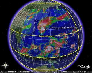
Talim Typhoon using real-time infrared image from GEOS 9 satellite

Copyright © 2005 Ee. All rights reserved

I am getting real with Google Earth.

Recently, I have equipped my Google Earth with real-time data like global infrared images, global cloud map, global water vapor, and a few cool things that are possible with it. Now, it is a chance of me becoming a weatherman, sort of!

I catch a glimpse of Talim Typhoon which has recently hit Taiwan and China. Now, It is heading towards Japan. And, it is big: its average radius is about 300-400km (it can engulf the whole Peninsula Malaysia with ease.)

0 Comments:

Post a Comment

<< Home