Googling the Earth with GPS

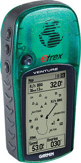
Garmin eTrex Venture—a 12 parallel channel GPS receiver
Copyright © 1996-2005 Garmin Ltd. All rights reserved
What will I do if I have a GPS receiver and Google Earth?
My company has a GPS receiver that we usually use to do accurate measurements during field trips. These trips are to determine the effective Line of Sight from given distances for our VHF radio products.
Our GPS receiver is a dry-cell battery-operated waterproof model with lots of features. The best feature I like most is its 1MB flash memory storage that allow users to store data and city map database (although, there is another model that offers more than 50MB memory space). This is very handy when we want to store markers to track from one point to another and view them in a chosen map. Another cool feature is its 5-point thumb stick (akin to IBM ThinkPad tracker) to navigate the cursor in a map or menus with a breeze.
More…
Because of its many features, its battery life would only last for about 20 hours in standby mode. Of course, if we keep turn on the GPS navigation, its battery life span will be shorter; usually around 5 to 6 hours.
Now, with the GPS receiver in my hands, I can improve my Google Earth by updating it with my places of interest.
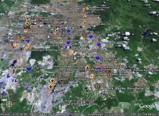
As for today, I put a lot of interesting places (while driving around Klang Valley) in my Google Earth. You can view it in the following picture:
Klang Valley
Copyright © 2005 Ee. All rights reserved


0 Comments:
Post a Comment
<< Home